Point Analyst 1.0

Designed for the exploratory analysis of spatial sampling and analysis methods
Rating
Your vote:
Latest version:
1.0 See all
Developer:
Dr. Rob Rempel
Screenshots
1 / 1
Awards (1)
Show all awards
Software Informer Virus Free award
Demo
Used by 1 person
Trusted Download
739 KB

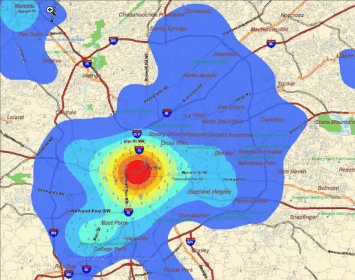
Point Analyst is an extension to the ArcView® GIS designed for the exploratory analysis of spatial sampling and analysis methods.
New users should read the concepts section to understand the motivation and principles behind the stratified interpolation function provided in the extension.
-Stratified interpolation: Point interpolation using ordinary point or universal kriging, logistic, spline, and inverse density weighting. Option to perform unstratified (global) interpolation.
-Generate reference map: Ability to generate a simulated reference map for a response variable (e.g., bird density) based on habitat relationships and specified variance.

Comments

User

Your vote:

Related software

Google Earth Pro
Google Earth Pro
Free
rating

Shareware program for earth-mapping learners of all ages.

Decision Analyst STATS
Free
rating

Windows-based statistical software program for marketing research.

WAsP Climate Analyst
Free
rating

WAsP Climate Analyst performs analyses on time-series of meteorological data.

CellProfiler-Analyst
Free
rating

Explore and analyse data from image-based experiments.

LizardTech MrSID Plug-in for ArcGIS 3D Analyst
LizardTech MrSID Plug
Free
rating

LizardTech MrSID Plug-in for ArcGIS 3D Analyst loads point cloud datasets.

Related suggestions

Point analyst 1.0
Arcview 3.1 download